Introduction
Welcome! This blog will function as my diary/logbook as I go about developing a country from scratch on the fictional mapping platform OpenGeoFiction. Here is my country now:
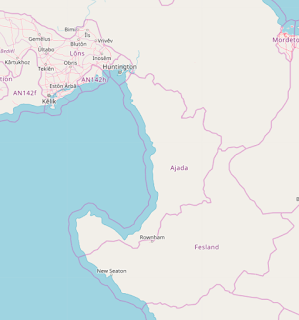

It's currently called "Ajada" which was an earlier name that I've now decided to change. I'm going with Embla for now, and we'll see where things lead. To create a broad picture of the country, which is located between -47 and -52 degrees in latitude, imagine an inland mountain range straddling the border running NW to SE, with a few broad river valleys emptying into the gulf(?), and a scattering of islands in the far north and extending off the peninsula in the far south. Another post will go over geology, and yet another on climate. But for now I'm going with a temperate rainforest (see the Pacific Northwest for inspiration) with a vibrant coastline and lots of terrestrial resources like timber and fertile land. Not imagining much in the way of mineral or fossil fuel resources, but definitely thinking of adding some kind of port hub. Check back for next steps and progress!


Comments
Post a Comment