Posts

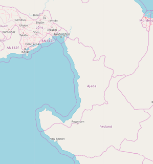
Revised Elevation Map

Image
I spent some more time playing around with the river systems and decided to shift things from the last draft. I'm not sure about the lake geography. I'm going to try to look for examples of other lakes to better refine the size. I definitely want some kind of large-ish lake in the middle, but there will be other finger lakes in the northern mountains, I haven't reached that level of detail yet. Next steps are tracing this map into JOSM to get a rough outline of rivers and some administrative boundaries. The dotted lines are what I envision as states/districts/region type things. The Northern district is the biggest but also likely the less populated. The middle two will probably have about even population, the capital city is in the middle district at the mouth of the largest river. I'm excited to design that area eventually. The southern two districts are much smaller. I'm not sure if having them split into two is justified unless there was another major city cente...

Draft Elevation Map!

Image
Following the advice of OGF's Making Realistic Countries , I used Inkscape to trace Embla and draw a preliminary elevation map: Which I then used to imagine some major waterways, mostly rivers and some lakes: And then from there, I placed cities and large towns where people might be most likely to settle: I'm definitely going to continue to tweak the elevation model and the rivers. I wanted district/state boundaries to be based on watershed-type areas. I have to think about the terrain outside of my country boundaries as well, to make things look continuous and more realistic. I'm very happy with this rough draft though!

Hand-drawn Draft Map

Image
Doing more research tonight on climate and thinking more about geography/geology. I used the handy OGF Scale Helper  to find some interesting/inspirational places in the real world. Those images gave me a very broad idea of what I was thinking for each region. You kind of have to use your imagination as some of the real world features would be mirrored or oriented differently on my map. I would 10/10 recommend using the scale helper to really get a sense of how big your space is, or if you're not mapping on OGF use some sort of real-life barometer, because I definitely thought my country was smaller than it really is! Region 1 & 2: Upper Third I'm thinking since the mountain range is running NW>SE, that the northern part of my country will be a coastal part of the range, which glacial valleys/fjords and rocky islands. The mountains would gradually move away from the coastline as you travel south so you would get more land in the glacial valleys and some nice riv...

Introduction

Image
Welcome! This blog will function as my diary/logbook as I go about developing a country from scratch on the fictional mapping platform OpenGeoFiction . Here is my country now: It's currently called "Ajada" which was an earlier name that I've now decided to change. I'm going with Embla for now, and we'll see where things lead. To create a broad picture of the country, which is located between -47 and -52 degrees in latitude, imagine an inland mountain range straddling the border running NW to SE, with a few broad river valleys emptying into the gulf(?), and a scattering of islands in the far north and extending off the peninsula in the far south. Another post will go over geology, and yet another on climate. But for now I'm going with a temperate rainforest (see the Pacific Northwest for inspiration) with a vibrant coastline and lots of terrestrial resources like timber and fertile land. Not imagining much in the way of mineral or fossil fuel resources...